
Rūaumoko’s Warning: What Napier’s Earthquake Memory Can Tell Shimla

A visit to Napier’s Shockwave Earthquake exhibition offers more than a look into New Zealand’s past. The story of the devastating 1931 Hawke’s Bay earthquake also raises important questions for Himalayan towns such as Shimla, where seismic risk, steep terrain and an increasingly dense built environment exist together.
Remembering the Hawke’s Bay Earthquake
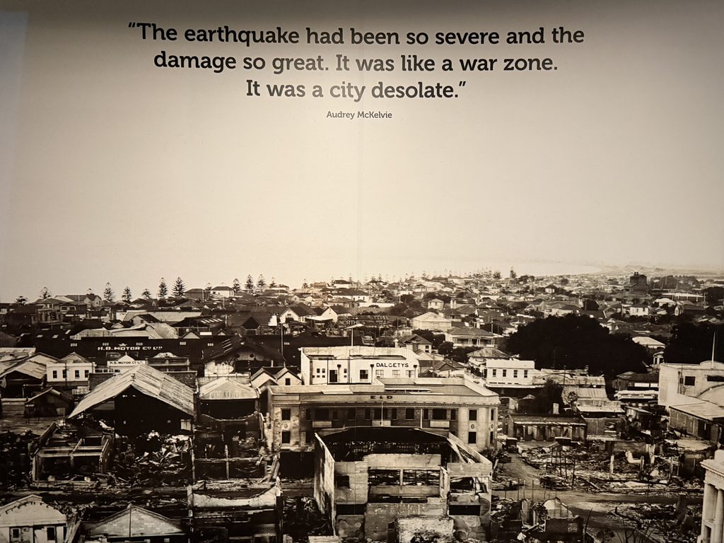
At 10:47 am on 3 February 1931, a powerful earthquake struck Hawke’s Bay in New Zealand. Napier and Hastings suffered extensive destruction, and 256 people lost their lives.
The earthquake became one of the defining events in the region’s history. Napier was later rebuilt, much of it in the Art Deco style for which the city is now widely known. The disaster also became part of public memory through museums, historical displays and earthquake preparedness education.
The Shockwave exhibition does not treat the earthquake simply as a historical event. It connects the past with present awareness, reminding visitors that living in a seismically active region requires preparation as well as memory.
For those familiar with the Himalayas, the comparison with Himachal Pradesh is difficult to ignore.
Different Continents, Active Tectonic Regions
Napier and Himachal Pradesh lie in very different parts of the world, but both are shaped by powerful tectonic processes. New Zealand lies along the boundary between the Pacific and Australian plates. The Himalayas were formed through the continuing collision of the Indian and Eurasian plates.
Himachal Pradesh has its own historical evidence of the consequences.
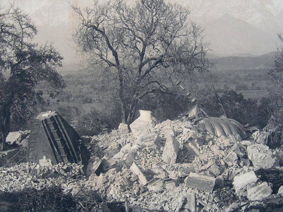
On 4 April 1905, the Kangra earthquake caused widespread destruction across the region and became one of the deadliest earthquakes in Indian history. Other damaging earthquakes across the Himalayan belt, including Uttarkashi in 1991 and Chamoli in 1999, have continued to demonstrate the seismic nature of the region.
These events make earthquake preparedness a continuing issue rather than a matter belonging only to the past.
Himachal Pradesh’s Seismic Risk
Under India’s presently applicable seismic standard, Himachal Pradesh includes areas classified within Zones IV and V, representing high and very high seismic risk. For a brief period, the revised national seismic zonation introduced in 2025 placed the Himalayan arc within a newly created Zone VI. That revised zonation was withdrawn in March 2026, restoring IS 1893 (Part 1):2016 as the current standard.
The regulatory classification may change as scientific methods and national standards evolve, but the underlying geological reality does not. Himachal Pradesh remains a highly earthquake-prone Himalayan state.
For Shimla, earthquake hazard also intersects with another concern: the physical form of the city itself.
Shimla’s Built Environment Adds to the Concern
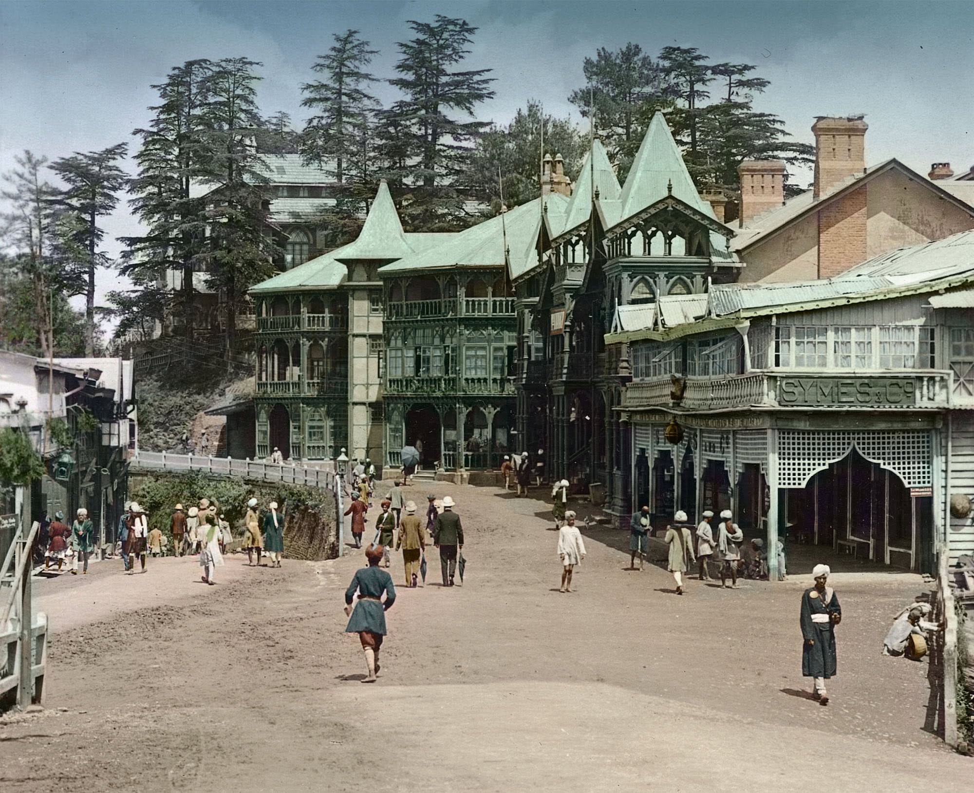
Shimla developed historically as a hill town for a much smaller population. Today, development extends across steep slopes where construction, slope cutting, building density and access all influence disaster vulnerability.
An expert committee considered by the National Green Tribunal recorded serious concerns about Shimla’s built environment. It observed that many buildings had been constructed on steep terrain, including slopes exceeding 45 degrees and, in some cases, 70 degrees.
The committee also identified structural concerns such as soft storeys, irregular building forms, inadequate foundations, buildings constructed closely together and other weaknesses relevant to earthquake safety.
Its recommendations included stronger building controls, slope stability requirements, seismic safety measures and assessment of vulnerable structures.
The NGT Proceedings and Shimla’s Development Plan
These concerns became part of a long legal proceeding before the National Green Tribunal in the matter initiated by Yogendra Mohan Sengupta.
On 16 November 2017, the NGT imposed major restrictions on construction in the Shimla Planning Area. New residential, institutional and commercial construction was prohibited in core and green or forest areas, while construction elsewhere was restricted to two storeys and an attic, subject to specified conditions.
The Tribunal also directed the state to prepare a development plan while considering environmental protection, disaster vulnerability and the recommendations placed before it.
The state’s review application was dismissed in July 2018.
A Draft Shimla Development Plan was subsequently prepared in 2022. The NGT stayed the draft in May 2022 and later held in October 2022 that it conflicted with its earlier directions.
The matter eventually reached the Supreme Court.
On 11 January 2024, the Supreme Court held that preparation and approval of a development plan under the Himachal Pradesh Town and Country Planning Act involved delegated legislative powers and that the NGT had exceeded its jurisdiction by directing how those powers should be exercised.
The Court set aside the relevant NGT orders and permitted the State of Himachal Pradesh to proceed with implementation of the Shimla Development Plan published in June 2023.
The judgment resolved the jurisdictional question surrounding the development plan. It did not, however, make Shimla’s underlying geological and structural vulnerabilities disappear.
The Missing Information Is at Building Level
Seismic zones describe broad levels of hazard. They do not answer one of the most practical questions for people living in a densely built hill city:
Which individual buildings are adequately prepared for a major earthquake, and which require strengthening or further structural assessment?
This is where building-level vulnerability information becomes important.
Rapid Visual Screening can be used as an initial assessment to identify characteristics associated with greater earthquake vulnerability. Buildings that raise concerns can then undergo detailed structural evaluation by qualified professionals.
Such assessments can consider factors including structural irregularity, soft storeys, close spacing between buildings, masonry construction, foundations, slope conditions and the age and design of a structure.
The expert committee considered by the NGT had already recommended seismic safety analysis of important lifeline buildings such as hospitals, administrative buildings and schools, along with measures for improving their safety.
A systematic and accessible understanding of building vulnerability would therefore add an important layer to broader seismic zoning and urban planning.
What Napier’s Experience Demonstrates
Napier’s earthquake museum shows the value of keeping disaster memory visible.
The 1931 earthquake is not presented only through dates and statistics. Historical photographs, personal accounts, damaged streets and public education connect the disaster with decisions made by later generations.
Preparedness messages such as “Drop, Cover, Hold” become part of ordinary civic knowledge rather than information encountered only after an emergency.
Shimla does not need to experience another historic disaster before earthquake awareness becomes equally visible.
The Kangra earthquake of 1905 already provides the region with its own historical warning. Scientific understanding of Himalayan seismicity provides another. Concerns recorded about Shimla’s steep slopes and building stock add a third.
The practical task is to convert that knowledge into preparedness.
For us, the lesson from Napier is therefore not simply about remembering an earthquake. It is about using memory, science, structural assessment and public awareness together so that known risks are understood before they become disasters.

Related Articles
More stories and updates worth exploring from our journey.